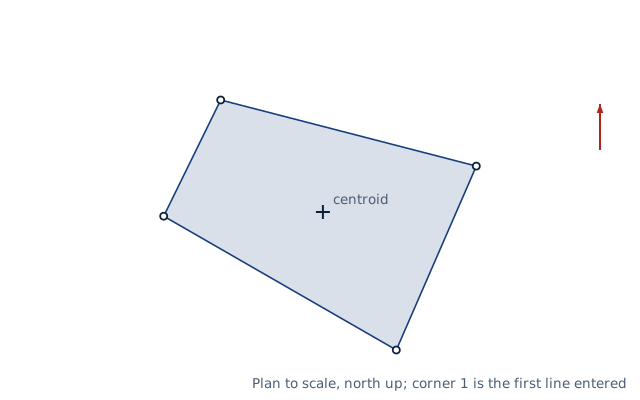
Drawn for the default inputs. It redraws as you change them.
Results are estimates. They do not replace the governing code, class or flag requirements, or a check by a competent person. Report a problem
Introduction
The area of a lot or any straight-sided figure follows directly from the coordinates of its corners. Multiply each x by the next y, subtract the next x times this y, add the results round the figure and halve the sum. This is the coordinate or shoelace method. A rectangle with corners at (0, 0), (100, 0), (100, 50) and (0, 50) ft gives 5 000 ft², or 0.115 acres.
This calculator takes a list of corner coordinates in feet, US survey feet or metres. It returns the area in m², ft², acres and hectares, the perimeter, the centroid and the direction of the corners. It warns when two edges cross. It is for surveyors, engineers, planners and landowners checking a plot from a survey plan, a traverse or GPS readings.
Formulas
Shoelace (Gauss) formula for n corners, with corner n + 1 equal to corner 1:
List the corners in order round the boundary. Corners out of order make the edges cross, and the page then warns that the area is wrong.
Edges are straight. Approximate a curved boundary by short chords, or add the segment areas of the arcs separately.
Grid coordinates such as UTM or state plane give a grid area. For the ground area, divide by the square of the combined scale factor.
The US survey foot is 1200/3937 m, about 2 parts per million longer than the international foot. Use it only for coordinates that were defined in it.
Worked example
A four-sided lot has these corners in feet, as easting and northing: (5 000.000, 5 000.000), (5 125.709, 5 256.247), (5 689.251, 5 110.519) and (5 512.926, 4 705.143). They are the adjusted points of the traverse example.
Move the origin to the first corner to keep the numbers small; the area does not change. The corners become (0, 0), (125.709, 256.247), (689.251, 110.519) and (512.926, −294.857).
Cross products round the figure: 0, then 125.709 × 110.519 − 689.251 × 256.247 = −162 725.27, then −259 918.55, then 0.
Sum: −422 643.82. It is negative, so the corners run clockwise.
Area: 422 643.82 / 2 = 211 322 ft².
In other units: 211 322 / 43 560 = 4.851 acres, or 1.963 hectares.
The perimeter is 1 901.20 ft and the centroid lies at easting 5 351.03, northing 5 009.28 ft.
The worked example, drawn by the same code as the live drawing above.
FAQ
How do I calculate the area of an irregular lot?
Get the coordinates of its corners from the survey plan or a GPS. Then apply the shoelace formula, as this page does, instead of splitting the lot into triangles.
Does it matter which corner I start with?
No. Any starting corner and either direction give the same area. Only the sign of the sum changes with direction.
Why is it called the shoelace formula?
Writing the x and y columns side by side and drawing the cross-multiplications between rows looks like the lacing of a shoe.
How many square feet are in an acre?
43 560 ft², which is 4 046.856 m². A hectare is 10 000 m², or 2.471 acres.
Can I use latitude and longitude?
Not directly, because degrees are not equal lengths. Convert the points to UTM first, then use the eastings and northings in metres.
What is the centroid used for?
It is the centre of area of the lot. Engineers use it for the resultant of a uniform load on a slab or the label point of a parcel on a map.
Before every release the calculator must reproduce each case below. The note under each case says where the expected answer comes from: a standard, a textbook, a published table, or a hand calculation shown in full.
A square of 208.7103 ft sides is 43 560 ft² = 1 acre = 0.404686 ha; a 100 m square is 1 ha = 2.471054 acresNIST Handbook 44, Appendix C: 1 acre = 43 560 ft² = 4 046.856 422 4 m²; 1 ha = 10 000 m²
Triangle (0,0), (6,0), (0,3): area 9, centroid (2, 1); L-shape 0–4 × 0–1 plus 0–1 × 1–4: area 7, centroid (1.5, 1.5)Geometry: triangle area ½ b h and centroid at the mean of the corners; composite centroid by moments (4 × (2, 0.5) + 3 × (0.5, 2.5)) / 7
Default lot (the adjusted traverse): shoelace sum −422 643.8 ft², so 211 322 ft², 4.851 acres, clockwise; the same in northing-easting order and with a closing repeat of the first pointHand calculation with the origin moved to the first corner: cross products 0, −162 725.27, −259 918.55, 0
US survey foot: a 1 000 × 1 000 survey-ft square is 92 903.41 m², 4 ppm more than in international feet (92 903.04 m²)NIST Handbook 44, Appendix C: US survey foot = 1200/3937 m; international foot = 0.3048 m
A bow-tie (crossing edges) warns; collinear corners, two points, a decimal comma and a lone number are refused; names before the coordinates are readBehaviour check: warnings and rejected inputs
Worked example of the article: the calculator reproduces 211 322 ft², 4.851, 1.963, 1 901.20 ft, 5 351.03 to the digits printedThe worked example on this page, to the digits printed
Assumptions and sources
Assumptions and limits
The corners are listed in order around the boundary, either clockwise or counter-clockwise, and the edges are straight lines that do not cross.
Coordinates are plane (grid) coordinates. On a map projection such as UTM or a state plane grid, the area is a grid area; divide it by the square of the combined scale factor for the ground area.
Curved boundaries must be broken into short chords or have their segment areas added separately.
An acre is 43 560 international square feet (4 046.856 m²). The US survey foot, 1200/3937 m, can be chosen for older US state plane coordinates.
Sources
Ghilani, C.D. and Wolf, P.R., Elementary Surveying: An Introduction to Geomatics, 13th ed., Pearson, ch. 12 Area (area by coordinates)
Bourke, P. (1988), Calculating the area and centroid of a polygon (signed area and centroid formulas)
NIST Handbook 44, Appendix C (1959 international foot 0.3048 m, US survey foot 1200/3937 m, acre 43 560 ft²)
Cite this calculator
Papandreou, C. (2026). Polygon area from coordinates (shoelace method) calculator. Engineering Bible. https://engineeringbible.com/civil/area-from-coordinates/
Embed this calculator on your site
Copy this HTML into your page. The calculator stays free to use and links back here.